


Intercomparison of submesoscale-permitting realistic ocean models are implemented under cloud-based framework
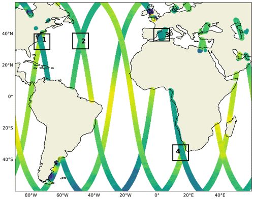
Fig. 1 SWOT tracks during its calibration phase and strategic Xover regions in the Atlantic sector. The regions cover the Gulf Stream separation and its extension (Regions 1 and 2), the western Mediterranean Sea (Region 3), and the Agulhas Rings (Region 4).
With the increase in computational power, ocean models with kilometer-scale resolution have emerged over the last decade. These models have been used for quantifying the energetic exchanges between spatial scales, informing the design of eddy parametrizations, and preparing observing networks. The explosion of model outputs makes it difficult to transfer and analyze the data, which are on the order of terabytes. Recently, the CLIVAR Ocean Model Development Panel, collaborated with community colleagues, used a cloud-based analysis framework proposed by the Pangeo project, to systematically assess the realism of the kilometer-scale resolution models, aiming to tackle the existed distribution and analysis challenges of the model output.

Fig. 2 A snapshot of surface relative vorticity normalized by the local Coriolis parameter on 1 February at 00:00 from each model in Region 1.
The output of eight submesoscale-permitting realistic simulations were analyzed all on the cloud, for a crossover region of the upcoming Surface Water and Ocean Topography (SWOT) altimeter mission near the Gulf Stream separation. The cloud-based analysis framework (i) minimizes the cost of duplicating and storing ghost copies of data and (ii) allows for a seamless sharing of analysis code and results amongst collaborators. In the paper, the authors described the framework and provided example analyses (e.g., sea-surface height variability, submesoscale vertical buoyancy fluxes, and comparison to predictions from the mixed-layer instability parametrization). Basin- to global-scale, submesoscale-permitting models are still at their early stage of development; their cost and carbon footprints are also rather large. It would benefit the community to document the different model configurations for future best practices.
An emphasis on data analysis strategies would also be crucial for improving the models themselves.
*************************************************************************************************
(Summary written by Dr. Takaya Uchida)
Uchida, T., Le Sommer, J., Stern, C., Abernathey, R. P., Holdgraf, C., Albert, A., Brodeau, L., Chassignet, E. P., Xu, X., Gula, J., Roullet, G., Koldunov, N., Danilov, S., Wang, Q., Menemenlis, D., Bricaud, C., Arbic, B. K., Shriver, J. F., Qiao, F., Xiao, B., Biastoch, A., Schubert, R., Fox-Kemper, B., Dewar, W. K., and Wallcraft, A.: Cloud-based framework for inter-comparing submesoscale-permitting realistic ocean models, Geosci. Model Dev., 15, 5829–5856, https://doi.org/10.5194/gmd-15-5829-2022, 2022.


Add new comment