WGOMD/SOP Workshop on Sea Level Rise, Ocean/Ice Shelf Interactions and Ice Sheets

Monday, February 18, 2013 to Wednesday, February 20, 2013
Event City: 
Hobart
Australia
Event Attendance: 
Closed

Location: 

Hobart, Australia

Date: 

Monday, 18 February, 2013 - Wednesday, 20 February, 2013
Workshop Flyer
Motivation
Workshop Objectives
Sponsors

Motivation

The proposed symposium is the next in a series of high-profile workshops held by the World Climate Research Program (WCRP) Climate Variability and Predictability (CLIVAR) Working Group on Ocean Model Development (WGOMD).  The CLIVAR program is a major international effort that aims to describe and understand the physical processes responsible for climate variability and predictability through analysis, observation, and modeling efforts. The WGOMD is responsible for stimulating ocean model development, along with promoting interaction amongst the ocean modeling community and between this and other climate related research communities. We will bring together leading international scientists and early-career researchers from the ocean, ice-sheet, ice-shelf, and sea-level rise modeling and observational communities to explore the state-of-science and emerging pathways for development of the next generation of coupled climate models.

We aim to advance the state-of-knowledge of projections of future sea level by focusing on two major scientific challenges. Firstly, what is the global sea-level rise contribution from the stability (or otherwise) of ice-sheet mass exchanges with the oceans. Secondly, what is the regional signature of sea-level rise associated with the mass redistribution of both the changing ocean and ice sheets. Together, these components of sea-level rise inform knowledge of potential coastal impacts, and contribute to the understanding of a topic currently drawing intense scientific and societal interest.

Ocean modeling, especially as a part of coupled climate modeling, is a fundamental component of the projection of future sea-level rise. This is particularly true for the regional patterns of sea-level variability and change. The ocean modeling community faces significant outstanding challenges regarding projection of future sea-level. Problems of ocean model bias and drift have not to date been sufficiently addressed, despite the importance of this for interpreting the wealth of model outputs now available through CMIP5. The WGOMD, through its ongoing role in promoting Coordinated Ocean-Ice Reference Experiments [COREs: Griffies et al., 2009; Griffies et al., 2012] is in a unique position to help identify and address the deficiencies of ocean models relevant to our understanding of global and regional sea-level projections. As such, the identification of the strengths and weaknesses of ocean models with respect to sea level change is also a key aim of the workshop.

The above aims, along with the objectives below, are specifically designed to be both educational and stimulating to the early career scientists that we will actively encourage to participate.


Workshop Objectives:

1.     Evaluation of state-of-science of ocean and land-ice interactions.

2.     Identify priorities for reducing uncertainties in the projections of global and regional   sea-level rise.

3.     Investigate pathways for the development of the next generation of climate models incorporating interactive land-ice components.


Sponsors:

Climate Variability and Predictability Project (CLIVAR)
Commonwealth Scientific and Industrial Research Organisation (CSIRO)
Climate and Cryosphere Project (CliC)
World Climate Research Programme (WCRP)
Intergovernmental Oceanographic Commission (IOC)
US National Aeronautics and Space Administration (NASA)
US CLIVAR
Antarctic Climate and Ecosystems Cooperative Research Center (ACE CRC)
Australian Research Coucil Centre of Excellence for Climate System Science
US Department of Energy


Gokhan Danabasoglu (WGOMD co-chair): National Center for Atmospheric Research, USA

Helge Drange (WGOMD co-chair): University of Bergen, Norway

Matthew England (SOP co-chair): University of New South Wales, Australia

Kevin Speer (SOP co-chair): Florida State University, USA

Simon Marsland, CSIRO Marine and Atmospheric Research, Australia

John Church, CSIRO Marine and Atmospheric Research, Australia

Catia Domingues, Antarctic Climate and Ecosystems CRC, Australia

Stephen Griffies, NOAA/Geophysical Fluid Dynamic Laboratory, USA

David Holland, Courant Institute of Mathematical Sciences, New York University, USA

Anna Pirani, CLIVAR Project Office, UK

Patrick Heimbach, Massachusetts Institute of Technology, USA

The following provides a list of some key questions. Some of them have been previously raised in the outcomes of previous workshops [e.g. the Breakout Group Reports contained in IPCC, 2010] and remain as significant challenges to the scientific community. We hope that the workshop participants will address these and other related questions in their presentations, posters, and discussions.


1.     Sea-level rise: What are the main contributions to sea-level rise? What are the relative contributions of, for example, steric changes in the ocean versus addition of mass to the ocean from land-ice sources?


2.     Ocean/ice-shelf interactions: What is the state-of-science in both the observation and modeling of sub-ice shelf processes? How might these processes change in a changing climate? What are the relative roles of basal melt, basal accretion, and calving, in determining the current and future evolution of ice-shelves? How might changes in mean or extreme winds affect ice-shelves? What role might be played by sea-ice in buffering ice-shelves from tides and surface waves? What are the effects of increased ice-shelf meltwater injection on local ocean/sea-ice interactions?


3.     Ice-sheet observation and modeling: How well do we understand the current mass balance, including its spatial variability, of the Antarctic and Greenland ice-sheets? What is the state-of-science in ice-sheet modeling? What are the relative roles of ice dynamics and of surface mass balance in determining current and future changes?


4.     Ice-sheet/ice-shelf interactions: How will possible increased melting or break-up of ice-shelves affect ice-sheets? What is the role of ice-shelves on adjoining ice stream dynamics? How well are dynamical ice-sheet models able to simulate ice flow? Are these models capable of predicting the response to changes in the system?


5.     Ocean modeling: Which of the identified processes contributing to sea-level rise are well represented by current ocean models? What is the relative importance of steric contributions to sea-level rise compared to the mass induced contributions from ice-sheet melting? How well are ocean and coupled climate models able to predict changes in ocean warming at the ice-sheet margins? What role might sea-ice or polynyas play in moderating or amplifying ocean changes at the ice-sheet margins? How can the use of observations enlighten our understanding of ocean and sea-ice processes adjacent to Greenland and Antarctica? How can we reduce long-term drift in ocean climate models?


6.     Next-generation climate models: How will our understanding of both global and regional sea-level rise change as ocean and climate models go to higher spatial resolution? What are the key development pathways towards fully coupled climate and ice-sheet models?

The three-day workshop will consist of sessions formed around the above topics. In addition to the invited talks, we will invite contributed talks and consider the possibility of poster presentations. The invited speakers will be asked to review the current state of research related to a particular topic with candid and critical comments, rather than focusing on their own research. Presentations will be conducive to discussion, and will be concluded by mandatory discussion sessions.


By careful design we shall avoid a themed workshop dominated by seemingly random talks that risk displays of speaker show-and-tell with the possibility of repetitiveness. Session conveners will promote discussion of future directions and how the community can move forward together both within the context of, and combining overall themes of, the various presentations within their sessions (for example on the analysis and bias-correction of projections from CMIP5, assessment of historical sea-level change in CORE forced ocean simulations, strategies to assess models against observations, the development of state of the art modeling systems, etc.). Session convenors will also endeavour to foster a comfortable environment suitable for open comment and discussion throughout the meeting, which is particularly useful for encouraging the active participation of early career researchers.


Those charged with leading the sessions and discussions will promote the main issues and points raised in their sessions, and these will be brought together into concluding discussions that investigate whether the community could develop a common framework towards tackling the key uncertainties of future sea-level change.


Welcome to the workshop application and abstract submission form!

Please fill in your contact details. You can submit a poster abstract as part of the registration process. Those wishing to apply for funding must include a poster abstract in their application.

Note that there is a registration fee of $150 to be paid in when registering for the workshop.

Registration has now closed.


Travel Support

A limited number of travel grants are available to enable and support participation of students, early career scientists and scientists from developing countries to attend the workshop. Applications will be reviewed by the Organizing Committee.

Grants will be assigned based on financial need and scientific merit of the proposed poster described in the abstract. Priority will be given to:

1) Students: those pursuing their graduate studies (MSc, PhD)
2) Early Career Scientists: post-graduates and researchers who received their highest degree in 2005 or later
3) Scientists from emerging and developing economies

Grantees must attend the entire conference in order to benefit from the financial support.
If you wish to apply for travel support, please submit a poster abstract and provide to a short CV.

We strongly encourage the applicant to secure a significant proportion of financial support from national/institutional sources. Please include information on alternate sources of funding when you complete the registration form.

Improved Antarctic Surface Mass Balance Remote Sensing using ASCAT
A. D. Fraser1, S. Wotherspoon2, H. Enomoto3, N. W. Young1,4.
1 Antarctic Climate & Ecosystems Cooperative Research Centre, University of Tasmania, Australia
2 Institute for Marine and Antarctic Studies, University of Tasmania, Australia
3 National Institute of Polar Research, Japan
4 Australian Antarctic Division, Australia

Elephant seals confirm the dense Shelf Water sources for Cape Darnley Bottom Water, offering cost-effective long-term monitoring of Prydz Bay and surrounds
G. Williams1, F. Roquet2, L. Herraiz-Borreguero1, I. Field3, M. Hindell4, T. Tamura5
1 ACECRC
2 Department of Meteorology, Stockholm University
3 Macquarie University, Australia
4 Institute for Marine and Antarctic Studies, Australia
5 National Institute of Polar Research, Tachikawa, Japan

Past and future sea-level change from the surface mass balance of glaciers
B. Marzeion, A. H. Jarosch, and M. Hofer

Institute of Meteorology and Geophysics, University of Innsbruck, Austria

Tidal Effects on Ice Shelves in the Amundsen Sea
R. Robertson

Univ. of New South Wales Canberra, Australia

Impact of self-attraction and loading effects induced by shelf mass loading on projected regional sea level rise
K. Richter1,2, R. E. M. Riva3, and H. Drange1,2,4

1 Geophysical Institute, University of Bergen, Norway.
2 Bjerknes Center for Climate Research, Norway.
3 Dept. Geoscience and Remote Sensing, Delft University of Technology, Netherlands
4 Uni Research AS, Norway

Recent status of development of a numerical ice sheet/shelf/stream model ICIES
F. Saito1, A. Abe-Ouchi1, K. Takahashi1 and T. Obase2

1 Japan Agency for Marine-Earth Science and Technology
2 Atmosphere Ocean Research Institute, University of Tokyo

Melting of the Greenland ice sheet and its climate impact over the next centuries in an Earth system model
W. Wei, G. Lohmann, D. Barbi, K. Grosfeld and M. Thoma

Alfred Wegener Institute for Polar and Marine Research, Germany

Simulations of ocean-ice shelf interactions in the Parallel Ocean Program (POP)
X. Asay-Davis1,2, M. Maltrud3

1 New York University, USA
2 Potsdam Institute for Climate Impact Research, Germany
3 Los Alamos National Laboratory, USA

Comparison of Steric Sea Level from an Ensemble of Ocean Reanalyses and Objective Analyses
Andrea Storto* and the CLIVAR/GSOP intercomparison Group
*Centro Euro-Mediterraneo per I Cambiamenti Climatici (CMCC), Italy

Southern Ocean climate in a suite of forced global ocean-ice simulations
R. Farneti and the CORE-II participants

Earth System Physics Section, International Centre for Theoretical Physics, Italy

Sea Level Variability in the Community Earth System Model
S. C. Bates and Y.-H. Tseng

NCAR, USA

CESM simulation study about the AMO impacting on Antarctic Climate and Sea-Ice during Austral Summer
X. Li

New York University, USA

Snowfall-driven mass change on the East Antarctic Ice Sheet
Carmen Boening, Matt Lebsock, Felix Landerer, and Graeme Stephens
Jet Propulsion Laboratory, California Institute of Technology, USA

Sea level rise during surface warming hiatus periods
N. Maher1,2, M. England1,2 and A. Sen Gupta1,2

1 Climate Change Research Centre, University of New South Wales, Australia
2 Australian Research, Council Centre of Excellence for Climate System Science, Australia

Projection of subtropical gyre circulation changes and associated sea level changes in the Pacific
X. Zhang, J. A. Church, S. Platten and D. Monselesan
Centre for Australian Weather and Climate Research, CSIRO Marine and Atmospheric Research, Australia

Ocean and Land-Ice Interaction: Consequences of Sea-Level Rise in Bay of Bengal in Indian Ocean
Sahana Bose
Jawaharlal Nehru University, India

Shore line changes and Sea Level Rise along East coast of India: Implications to Climate Change
N. Jayaraju
Dept of Geology, Y.V.University, India

Subsidence in the coastal zone of Bangladesh
N. Mamnun

Nansen-Bangladesh International Centre for Coastal, Ocean and Climate Studies (NABIC), Bangladesh

Mass-induced and steric sea-level changes from ice-sheet melting
K. Lorbacher, S.J. Marsland, J.A. Church, S.M. Griffies and D. Stammer

Toward a new generation climate model: resolving multiscale processes in the ocean
Q. Wang, D. Sidorenko, T. Rackow, T. Semmler, R. Timmerman, X Wang, S. Danilov, J. Schröter, T. Jung
Alfred Wegener Institute for Polar and Marine Research, Germany

Mesoscale eddy contributions to the meridional transports of freshwater in the ocean
A.M. Treguier1, J Deshayes1, C. Lique2, J.M. Molines3
1 Laboratoire de Physique des Océans, CNRS-Ifremer-IRD-UBO, France
2 Joint Institute for the Study of Atmosphere and Ocean, University of Washington, USA
3 LEGI, France

Physical constraints on the energetics of bottom and deep water sinking and on rates of conversion between potential and kinetic energy in the ocean
J. A. Saenz, A. Hogg, R. Griffiths, P. Spence

Modelling Antarctic Bottom Water (AABW) Overflow in Global Climate Models
Kate Snow1, Dr Andy Hogg1, Dr Stephanie Downes1, Dr Bernadette Sloyan2, Dr Marshall Ward1
1 Research School of Earth Sciences and ARC Centre of Excellence for Climate System Science, The Australian National University, Australia
2 Centre for Australian Weather and Climate Research, CSIRO, Australia


Improved Antarctic Surface Mass Balance Remote Sensing using ASCAT
A. D. Fraser1, S. Wotherspoon2, H. Enomoto3, N. W. Young1,4
1 Antarctic Climate & Ecosystems Cooperative Research Centre, University of Tasmania, Australia
2 Institute for Marine and Antarctic Studies, University of Tasmania, Australia
3 National Institute of Polar Research, Japan
4 Australian Antarctic Division, Australia

Large scale distribution of Antarctic Surface Mass Balance (SMB) is currently poorly understood. High quality in situ measurements of SMB are sparse, particularly in the interior of the continent. Remotely-sensed parameters can be used to guide interpolation between in situ measurement. Traditionally, the passive microwave (C-band) polarisation ratio, which is sensitive to layers of different dielectric properties in the upper snowpack (a proxy for SMB), has been used to guide interpolation of SMB points. We present evidence that alternative parameters may be more suitable maps upon which to base interpolated fields. These maps come from the EUMETSAT ASCAT C-band scatterometer, which was launched in 2007. These maps are sensitive to recently-mapped extensive areas of surface wind glaze which are areas of near-zero net accumulation, and thus are less prone to overestimation of SMB compared with earlier large-scale SMB maps. A primary output of this work will be a new SMB map of the Antarctic continent based on these improved fields.

Elephant seals confirm the dense Shelf Water sources for Cape Darnley Bottom Water, offering cost-effective long-term monitoring of Prydz Bay and surrounds
G. Williams1, F. Roquet2, L. Herraiz-Borreguero1, I. Field3, M. Hindell4, T. Tamura5
1 ACECRC
2 Department of Meteorology, Stockholm University
3 Macquarie University, Australia
4 Institute for Marine and Antarctic Studies, Australia
5 National Institute of Polar Research, Tachikawa, Japan

Antarctic Bottom Water (AABW) production, from the downslope mixing of Dense Shelf Water (DSW), supplies the abyssal layer of the world ocean and is vital to the global climate system. A local variety of AABW has long been indentified in the eastern sector of the Weddell-Enderby Basin, but its precise DSW source and downslope mixing pathways have been elusive until now. Recently, the first observations of newly formed AABW cascading down the continental slope near 68ºE have refocused attention on the enhanced sea ice production in the polynyas of Cape Darnley and Prydz Bay. Here we document the DSW sources for this ‘Cape Darnley’ Bottom Water (CDBW), using unique data from instrumented southern Elephant seals (Mirounga leonina). We present the first observations of i) very high salinity DSW (>34.8) on the Cape Darnley shelf region and ii) the subsequent overflows of modified Shelf Water on the upper continental slope north of Cape Darnley. This study cements the resurgent story of CDBW and represents an important shift in our understanding of total and regional AABW production.

Past and future sea-level change from the surface mass balance of glaciers
B. Marzeion, A. H. Jarosch, and M. Hofer

Institute of Meteorology and Geophysics, University of Innsbruck, Austria

We present a model of the global surface mass balance of glaciers, based on the reconstruction and projection of the surface mass balance of all the world's individual glaciers, excluding the ice sheets in Greenland and Antarctica. The model is validated using a leave-one-glacier-out cross validation scheme using 3997 observed surface mass balances of 255 glaciers, and against 756 geodetically observed, temporally integrated volume and surface area changes of 341 glaciers. When forced with observed monthly precipitation and temperature data, the world's glaciers are reconstructed to have lost mass corresponding to 114+/-5 mm sea level equivalent (SLE) between 1902 and 2009. Using projected temperature and precipitation anomalies from 15 coupled general circulation models from the Coupled Model Intercomparison Project phase 5 (CMIP5) ensemble, they are projected to lose additionally either 148+/-35mm SLE (scenario RCP26), 166+/-42mm SLE (scenario RCP45), 175+/-40(mm SLE (scenario RCP60), or 217+/-47mm SLE (scenario RCP85) during the 21st century. Based on the extended RCP scenarios, glaciers are projected to approach a new equilibrium towards the end of the 23rd century, after having lost either 248+/-66mm SLE (scenario RCP26), 313+/-50mm SLE (scenario RCP45), or 424+/-46mm SLE (scenario RCP85). Up until approximately 2100, ensemble uncertainty within each scenario is the biggest source of uncertainty for the future glacier mass loss; after that, the difference between the scenarios takes over as the biggest source of uncertainty. Ice mass loss rates are projected to peak 2040-2050 (RCP26), 2050-2060 (RCP45), 2070-2090 (RCP60), or 2070-2100 (RCP85).

Tidal Effects on Ice Shelves in the Amundsen Sea
R. Robertson

Univ. of New South Wales Canberra, Australia

Tidal effects on circulation under the ice shelves and melting of the ice shelves in the Amundsen Sea were investigated using a numerical tidal model, comparing simulations with and without tides.  Tidal effects were found to depend on the location of the ice shelf with respect to the M2 effective critical latitude, which is where the tidal frequency equals the inertial frequency adjusted by relative vorticity, such as that associated with a wind-driven gyre.  For ice shelves located equatorward of the effective critical latitude, tides increased both mixing in front of and under the ice shelf and flow into the ice shelf cavities by as much as a 50%, despite weak tides compared to the mean flows.  Tides also increased melting for these ice shelves by 2-3 m yr-1.  For ice shelves located poleward of the critical latitude, tides retarded flow into the cavity and slightly reduced melting.

Impact of self-attraction and loading effects induced by shelf mass loading on projected regional sea level rise
K. Richter1,2, R. E. M. Riva3, and H. Drange1,2,4

1 Geophysical Institute, University of Bergen, Norway.
2 Bjerknes Center for Climate Research, Norway.
3 Dept. Geoscience and Remote Sensing, Delft University of Technology, Netherlands
4 Uni Research AS, Norway

Presently, global sea level rise at a rate of 3 mm/yr and is expected to continue to rise in the future. The rise is not spatially uniform but varies geographically. This is mainly due to non-uniform steric changes and the uneven distribution of meltwater from land ice. The investiagtion of these steric changes and its implications is the purpose of this study. We use 20 models participating in CMIP5 (RCP8.5) to compute global average steric height changes and regional sea surface height (SSH) changes. In addition, the Norwegian Earth System Model (NorESM1-M) is used to investigate regional steric height changes and SSH changes due to redistribution of sea water, and to quantify the magnitude of self attraction and loading (SAL) effects for three RCP-scenarios. We find that, depending on the scenario and region, SAL effects may result in an additional sea level rise of 1-3 cm on the world's continental shelf areas by the end of the 21st century. These estimates are at most 15 % of the combined changes in sea surface height induced by redistribution of water masses and steric expansion.

Recent status of development of a numerical ice sheet/shelf/stream model ICIES
F. Saito1, A. Abe-Ouchi1, K. Takahashi1 and T. Obase2

1 Japan Agency for Marine-Earth Science and Technology
2 Atmosphere Ocean Research Institute, University of Tokyo

Ice sheet model for Integrated Earth-system Studies (ICIES) has been developed to simulate Greenland and Antarctic ice sheets as well as paleo-climate studies of past Northern Hemisphere ice sheets.

Now we have been restructuring and improving the model to implement

  • MPI parallelization for higher-resolution experiments
  • Shallow-shelf approximation and Shelfy-stream approximation for better understanding of past/future migration of grounding-line

In this study, we report the recent status of development of ICIES and demonstrate it under ideal as well as realistic conguration such as:

  • Sensitivity of response of Greenland ice sheet to global warming on surface mass balance parameterization and reference climate states, using shallow-approximation model
  • Sensitivity studies of grounding line migration under MISMIP-type conguration and Antarctic ice sheet

Melting of the Greenland ice sheet and its climate impact over the next centuries in an Earth system model
W. Wei, G. Lohmann, D. Barbi, K. Grosfeld and M. Thoma

Alfred Wegener Institute for Polar and Marine Research, Germany

Rapid mass loss of the Greenland Ice Sheet (GrIS) has been observed in the last decades, which is attributed to the anthropogenic induced global warming. During the melting of the GrIS, the albedo effect and the elevation effect have strong positive feedback on the temperature change, both locally and globally. Its melting brings huge amount of freshwater into the North Atlantic, contributing to the global sea level rise and potentially changing the ocean circulation. Considering that the greenhouse gas will keep increasing as indicated by the IPCC emission scenarios, it is crucial to investigate the mass balance of the GrIS over the next centuries and its possible climate influence, e.g. sea level rise. In this study, we perform the IPCC AR5 scenarios using the Earth system model COSMOS with and without dynamic ice sheets. The results will allow us to predict the future GrIS mass balance and give both temporal and spatial evolution of the GrIS over the next centuries under different greenhouse gas concentrations. Comparison between different setups can be served as a constraint for the current IPCC models to estimate their biases of various climate parameters when there is no dynamic ice sheet included. Meanwhile, the potential impact of the GrIS melting on the global climate will be presented.

Simulations of ocean-ice shelf interactions in the Parallel Ocean Program (POP)
X. Asay-Davis1,2, M. Maltrud3

1 New York University, USA
2 Potsdam Institute for Climate Impact Research, Germany
3 Los Alamos National Laboratory, USA

We present a series of simulations using POP2X, a modified version of the LANL Parallel Ocean Program version 2 (POP2) that includes circulations in ice-shelf cavities. The geometry of the ice-shelf/ocean interface is represented using the partial top cells, following the approach developed by Losch (2008). One of our test cases is an idealized domain reminiscent of the Ronne-Filchner Ice Shelf cavity. Vertical model resolution can have a strong impact on the melt rate and circulation in the vicinity of the ice shelf. We have also performed decadal-scale simulations using a 0.1 degree Southern Ocean regional configuration of POP with four ice shelves (Ronne-Filchner, Ross, Amery, Pine Island). Including these shelves results in modified circulation and water properties in the cavities compared to a control run without ice shelves.

Comparison of Steric Sea Level from an Ensemble of Ocean Reanalyses and Objective Analyses
Andrea Storto* and the CLIVAR/GSOP intercomparison Group
*Centro Euro-Mediterraneo per I Cambiamenti Climatici (CMCC), Italy

During one of the last CLIVAR/GSOP and GODAE meetings, it was established a joint initiative among ocean synthesis producing centers in order to extensively compare some climate key parameters. CMCC is leading the intercomparison of the steric sea level (SSL), with the scientific objectives of i) quantify the global SSL, its uncertainty and the reanalyses skill with respect to independent estimates; ii) assess the regional SSL change and the agreement between the ocean reanalyses; iii) quantify the relative contributions of the thermal and haline components and iv) quantify the relative contributions of different vertical regions. We present here the first results from the intercomparison study, which involved 19 products, of which 15 ocean reanalyses and 4 observation-only products, thus representing a major effort in evaluating the SSL provided by the state-of-the-art ocean reanalyses.

The comparison strategy consists of a validation period (2005-2009) and an extended intercomparison period (1993-2009), the former covering the gravimetry era, while the latter the altimetry era. Within the validation period, the ocean synthesis products are compared with the independent SSL estimation given by monthly means of altimetric sea-level anomaly minus gravimetric ocean bottom mass anomaly, the latter from the ensemble of the GRACE RL05 solutions.

For the validation period, it turned out that the Global SSL (GSSL) fluctuations are quite well reproduced by the reanalyses, its ensemble mean leading to an anomaly correlation of 0.85 with the independent satellite estimates; the seasonality of the GSSL is generally well reproduced while linear trends exhibit large uncertainty and variability among the reanalyses and are generally under-estimated. Interestingly, the ensemble of the ocean reanalyses is more skillful than the ensemble of objective analyses (i.e. observation-only products), especially in areas with a poor observing network and/or impact of deep and bottom waters (e.g. ACC, Bering Sea). The ensemble mean itself proves a robust tool for further diagnostics.

For the extended intercomparison period, we generally found no consensus on the relative contributions of the thermal and haline components of the GSSL: while the halosteric contribution impact on the GSSL trend is generally neutral or slightly negative, there is no clear consensus on its contribution to the GSSL variability, its explained variance ranging from 2 to 75 % depending on the ocean. Finally, we have assessed the contribution of the “unobserved ocean” (considered below 700 m for the 1993-2009 period), which accounts for the 25% of the interannual signal variability in the case of the reanalyses ensemble. Further diagnostics focusing on the spatial patterns of the relative contributions are being assessed and will be presented as well.

Southern Ocean climate in a suite of forced global ocean-ice simulations
R. Farneti and the CORE-II participants

Earth System Physics Section, International Centre for Theoretical Physics, Italy

The Coordinated Ocean-Ice Reference Experiment (CORE) version II is an experimental protocol for ocean-ice coupled simulations forced with interannually varying atmospheric data sets for the period 1948-2007. This effort, involving several centers around the world, is coordinated by the CLIVARWorking Group on Ocean Model Development (WGOMD). The hindcast simulations provide a framework for both model evaluation and studying variability and change at seasonal to decadal time scales. Several regional studies are planned and currently underway.

We present an intercomparison that focuses on the recent evolution of the Southern Ocean as simulated by the different models. We focus on the mean state and variability of the Antarctic circumpolar current (ACC), the meridional overturning circulation (MOC), as well as water masses and their ventilation. To do this, we consider the evolution of the drivers of these circulations, both wind stress and buoyancy forcing, and of the interior structure of the Southern Ocean. Models of different resolutions are considered, from coarse to eddy-permitting/resolving, and an attempt is made to evaluate the role of mesoscale eddies and their parameterization. Comparison with observational estimates is made when possible. The identification of the strengths and weaknesses of ocean models with respect to the evolution of the Southern Ocean and its global consequences is also a key aim of the study.

Sea Level Variability in the Community Earth System Model
S. C. Bates and Y.-H. Tseng

NCAR, USA

The focus of this work is to examine the patterns of sea level variability in the Community Climate/Earth System Model (CCSM/CESM), which is tightly connected to the future ocean climate projection but to date has never been done. We will examine the modeled dominant modes of the sea level pattern variability in the north Atlantic and Pacific ocean basins and compare with satellite observations. The impacts of recent decadal warming and natural (internal) variability will be assessed using the 20th Century and 1850 control simulations. Consistent with observations, all five ensemble members of the 20th Century CCSM4 simulations exhibit accelerated surface warming in the late 20th Century.  We will investigate the modeled sea level variability and trending in relation to this warming. A long control simulation with no transient forcing, called the 1850 control simulation, will also be investigated and compared to examine the modeled natural (internal) sea level variability.

CESM simulation study about the AMO impacting on Antarctic Climate and Sea-Ice during Austral Summer
X. Li

New York University, USA

In this work, the relationship between the Atlantic Multidecadal Oscillation (AMO) and Antarctic regional climate and the sea-ice distribution are discussed. A series statistic analysis (Regression, EOF and Maximized Covariance Analysis) were performed, using ECMWF, MERRA and Hadley Center SST/Sea Ice reanalysis data, which shows that the AMO is highly related to the distribution of the sea ice around West Antarctica, as well as the Polar Climate. We then perform a series of simulation using CESM, by
changing the heat flux from the Ocean to the atmosphere (as well as the sea ice distribution, the Greenhouse Gas and Ozone). The results shows that the SST change in Atlantic region can enhance the deep convection, which further impact on subtropical jet, generate a Rossby Wave and propagate to
Antarctic Region. The linearity of Model response to the SST forcing are also discussed by dramatically changing the amplitude of SST forcing.

Snowfall-driven mass change on the East Antarctic Ice Sheet
Carmen Boening, Matt Lebsock, Felix Landerer, and Graeme Stephens
Jet Propulsion Laboratory, California Institute of Technology, USA

An improved understanding of processes dominating the sensitive balance between mass loss primarily due to glacial discharge and mass gain through precipitation is essential for determining the future behavior of the Antarctic ice sheet and its contribution to sea level rise. While satellite observations of Antarctica indicate that West Antarctica experiences dramatic mass loss along the Antarctic Peninsula and Pine Island Glacier, East Antarctica has remained comparably stable. In this study, we describe the causes and magnitude of recent extreme precipitation events along the East Antarctic coast that led to significant regional mass accumulations that partially compensate for some of the recent global ice mass losses that contribute to global sea level rise. The gain of almost 350 Gt from 2009 to 2011 is equivalent to a decrease in global mean sea level at a rate of 0.32 mm/yr over this three-year period.

Sea level rise during surface warming hiatus periods
N. Maher1,2, M. England1,2 and A. Sen Gupta1,2

1 Climate Change Research Centre, University of New South Wales, Australia
2 Australian Research, Council Centre of Excellence for Climate System Science, Australia

The anthropogenic increase in greenhouse gases in the atmosphere results in a radiative imbalance at the top of the atmosphere, which subsequently causes a non-linear increase in both land and sea surface temperatures. However, the observational record of surface air temperature reveals decadal periods with no significant change or in some cases a decrease in the global mean. These decades have been termed ‘hiatus’ periods. During these hiatus periods, there is still net increase in the input of radiation at the top of the atmosphere, and so the energy surplus must be modifying other components of the climate system. Here we examine what happens to this extra energy during hiatus periods.

We have undertaken an analysis of CMIP5 models, with a focus on the ACCESS model. Decadal long hiatus periods are identified within the models and assessed to test the hypothesis that the ‘missing’ energy is being used to heat the oceans below the sea surface. We investigate how and where deep ocean heat content anomalies penetrate the interior on decadal timescales. Where possible, comparisons with the observational record are made.

We use these results to compute sea level changes during hiatus periods. We examine the hypothesis that the extra energy is heating the oceans below the sea surface, so that although the sea surface is not significantly warming, sea level will rise due to warming in the sub surface ocean.

Projection of subtropical gyre circulation changes and associated sea level changes in the Pacific
X. Zhang, J. A. Church, S. Platten and D. Monselesan
Centre for Australian Weather and Climate Research, CSIRO Marine and Atmospheric Research, Australia

According to the intergovernmental Panel on Climate Change (IPCC) Fourth Assessment Report (AR4), sea level is projected to rise globally under different emission scenarios. The sea level changes are not going to be geographically uniform, with many regions departing significantly from the global average. Some of regional distributions of sea level changes can be explained by projected changes of ocean density and dynamics. In this study, with 11 available Coupled Model Intercomparison Project Phase 3 (CMIP3) climate models, we identify an asymmetric feature of projected subtropical gyre circulation change and associated sea level change between the North and South Pacific, through analysing projected changes of related parameters, such as ocean dynamic height (with reference to 2000 db), depth integrated steric height, Sverdrup stream function, surface wind stress and its curl. Poleward expansion of subtropical gyres is projected in the upper ocean for both North and South Pacific. Contrastingly, the subtropical gyre circulation is projected to spin down for about 20% in the subsurface North Pacific from the main thermocline around 400 m to at least 2000 m, while the South Pacific subtropical gyre is projected to strengthen for about 25% and expand poleward in the subsurface to at least 2000 m. Such asymmetrical distribution of the projected subtropical gyre circulation changes is directly related to differences in projected changes of temperature and salinity between the North and South Pacific, forced by surface heat and freshwater fluxes, and surface wind stress changes.

Ocean and Land-Ice Interaction: Consequences of Sea-Level Rise in Bay of Bengal in Indian Ocean
Sahana Bose
Jawaharlal Nehru University, India

The world’s largest mangrove-dominated Sundarbans delta situated between India and Bangladesh at the mouth of Bay of Bengal, contributes to the maximum deposits of terrestrial sediments along with glacial melt water throughout the year in Indian Ocean. This giant delta is feed by the Ganges, Brahmaputra and Meghna Rivers which contributes about a billion tons (1012 kg) of sediments annually to the Bengal basin. Ganges and Brahmaputra originate in the still rising Himalayan orogenic belt and reach the sea across the tectonically active Bengal basin. Melting of Himalayan Glaciers due to global warming has created more rainfall and cloud burst in high altitudes leading to massive rock weathering along the upper course of the rivers. Here the chemical denudation rates are 2 to 3 times higher than the world’s average. Water and sediments discharge of the rivers is driven largely by the South West Monsoon with maximum discharge in the month of June to October. This addition of mass to the ocean from land-ice sources has brought drastic steric changes of the Indian Ocean in recent years.

Objectives: This paper finds out the recent thermosteric and halosteric changes in Bay of Bengal due to addition of land-ice in the form of glacial melt water and what will be its impact on the coastal communities and marine resources? How these changes are affecting the atmospheric circulations of that particular region, why there is increase in frequencies of storm surges and tropical cyclones. This study is restricted to the northern portion of Bay of Bengal of Indian Ocean. Its talks about the depletion of world’s largest mangrove forests due to sea level rise. Projected impacts of sea level rise and other conclusions are drawn from this study, which are useful for policy implications and for preparing new ocean-climate models.

Methodology: Satellite data, government documents and reports are consulted for analysis and interpretations.

Major Findings: This study is based on 10-15 years data (year 1995-2010) to show the recent sea level rise in Indian Ocean due to maximum addition of glacial melt water in Bay of Bengal. This sudden increase in sediments influx from the Himalayas crystalline rock complexes has increased ocean warming. It is also observed that within this particular period, both the temperate and ocean salinity has increased drastically. Till the year 2000, the annual sea level rise (SLR) was 0.12 inches but afterwards the figure is crossing above 0.20 inches every year. There is depletion of mangrove forest due to excessive saline waters at the tidal estuarine. This sea has become more vulnerable for the occurrence of storm surges and tropical cyclones. Rising sea-surface temperature (SST) is one of the main factors contributing to increase in the frequency of cyclones and storm surges along with other atmospheric factors. The SLR may aggravate monsoon flooding in Bangladesh and India and could have far reaching impacts on both future regional and global climate. The United Nations Intergovernmental Panel on climate change predicts further sea level rise will submerge 17 percent of Bangladesh by 2050. More research is needed to integrate remote-sensing data such as SST and salinity, and global atmosphere-hydrosphere-cryosphere models that assimilate a new climatic data types to study this particular region.

Shore line changes and Sea Level Rise along East coast of India: Implications to Climate Change
N. Jayaraju
Dept of Geology, Y.V.University, India

India has 7,516 km of coastline, of which the mainland accounts for 5,422 km, Lakshadweep Islands coast extends for 132 km and the Andaman and Nicobar Islands extends for 1,962 km. The shoreline is one of the rapidly changing linear features of the coastal zone which is dynamic in nature. The issue of shoreline changes due to sea level rise over the  next century has increasingly become a major social, economic and environmental concern to a large number of countries along the coast, where it poses a serious problem to the environment and human settlements. Shoreline recession as a result of rising sea level has been recognized as a potential near future hazard by a number of countries and this is same for the states of India along the coast. Today the issue of shoreline changes due to sea level rise which caused by Globe warming has increasingly become a major issues in terms of its impact on the population along the coastal area. Changes in mean sea level as measured by coastal tide gauges are called relative sea level Changes. In IPCC (Intergovernmental Panel on Climate Change) Third Assessment Report (2001) shows that global average surface temperature is projected to increase by 1.4 to 5.8° C over the period 1990 to 2100. This projected warming will be greater than that experienced over the last 10,000 years. Moreover, the global mean sea level is projected to rise by 0.09 to 0.88 m over the same period, as a result of the thermal expansion of the oceans, and the melting of glaciers and polar ice sheets. The physical effects of sea level rise are categorized into five types, inundation of low lying areas, erosion of beaches and bluffs, salt intrusion into aquifers and surface waters, higher water tables and increased flooding and storm damage. Sea level has been rising 1.7–1.8 mm/year over the last century and the rate has increased to 3 mm/year in the last decade. Sea level rise is contributing to coastal erosion in many places of the world .The tide gauge records at five coastal locations in India; Mumbai, Kolkata, Cochin, Kandla and Sagar Islands have reported an increase in sea level. The change in sea level appears to be higher on eastern coast compared to western coast. The average sea level rise for India has been reported as 2.5 mm/year since 1950’s The most significant and direct impact of the sea level rise may be the shoreline retreat and the loss of the coastal wetland as a result of the inundation of the low land. The impact of global warming-induced sea level has great significance to India due to its extensive low-lying densely populated coastal zone. This paper  attempts to find the time trend of the sea level rise and document the positive, significant and increasing trend for the majority of the monitoring stations along east coast of  India.

Subsidence in the coastal zone of Bangladesh
N. Mamnun

Nansen-Bangladesh International Centre for Coastal, Ocean and Climate Studies (NABIC), Bangladesh

Subsidence is one of the causes of variation in the relative sea level in local level. As Bangladesh is one of the most vulnerable countries, it is important to know the contribution of subsidence in sea level rise of Bangladesh for better projection of sea level change over her coast. The poster aims to give an overview of the rate and causes of in the coastal area of Bangladesh. Subsidence in the area is complex with no clear spatiotemporal pattern. Around the coast subsidence is 2-4 mm/year.

Mass-induced and steric sea-level changes from ice-sheet melting
K. Lorbacher, S.J. Marsland, J.A. Church, S.M. Griffies and D. Stammer

Sea level rise associated with idealized Greenland and Antarctic ice sheet melting events is examined
using the Australian global coupled ocean sea-ice model ACCESS that has a free surface formulation
and thus can simulate fast barotropic motions. The perturbation experiments follow the
Coordinated Ocean-ice Reference Experiment (CORE) version III.

The global mean sea level rises by 9 mm yr-1 after a polar meltwater input of 0.1 Sv (1 Sv ≡ 106 m3s-1). A linear relation between sea level rise and global meltwater input is further supported by
experiments in which idealized melting occurs only in a region east or west of the Antarctic
Peninsula, and when melting rates are varied between 0.01 Sv and 1.0 Sv. The results indicate that in
ocean models that do not explicitly represent the barotropic signal (because they use the virtual salt
flux boundary conditions), the barotropic component of sea level rise can be added off-line to the
simulated steric sea level evolution that is also connected with melt events.

However, for climate adaption in low-lying coastal and island regions, it is critical that the barotropic
sea level signal associated with melting events is taken into consideration. It leads to a sea level rise
within 7-8 days of the initialization from melting ice-sheets for all regions of the global ocean. This
fast mass-induced adjustment contrasts sharply with the slower adjustment associated with the one-order of magnitude smaller steric sea level signal.

Toward a new generation climate model: resolving multiscale processes in the ocean
Q. Wang, D. Sidorenko, T. Rackow, T. Semmler, R. Timmerman, X Wang, S. Danilov, J. Schröter, T. Jung
Alfred Wegener Institute for Polar and Marine Research, Germany

The Finite Element Sea-Ice Ocean Model (FESOM) allows to use variable mesh resolution with focus on particular regions. This is useful for resolving dynamically important regions and bathymetry controlled flows in an otherwise coarse large scale model. Examples of FESOM applications will be given in the poster for Antarctic ice cavity simulations, water hosing experiments for Greenland Ice Sheet melting, and studies on the Weddell Sea Bottom Water formation from the Ice Shelf Water in the southern Weddell Sea. FESOM has been coupled to the atmospheric model ECHAM. The coupled model has been evaluated with relatively coarse resolution, varying from 150 to 20km in the ocean and T63L47 resolution in the atmosphere. We show that the climate state simulated by FESOM/ECHAM is in most cases within the spread of other climate models. A first water hosing experiment using the coupled model indicates that uncertainties in coupled model simulations can be large and it is challenging to predict the impact of increased ice sheet melting on ocean dynamics and dynamical sea level, as shown in other studies. The new model will serve as a tool for examining the model uncertainty by taking model resolution as one of the key parameters, while its complexity could also make this task challenging.

Mesoscale eddy contributions to the meridional transports of freshwater in the ocean
A.M. Treguier1, J Deshayes1, C. Lique2, J.M. Molines3
1 Laboratoire de Physique des Océans, CNRS-Ifremer-IRD-UBO, France
2 Joint Institute for the Study of Atmosphere and Ocean, University of Washington, USA
3 LEGI, France

In the ocean, the budgets of water and salt are linked. They can be expressed through the freshwater balance. Mesoscale eddies are ubiquitous in the ocean, and contribute to the freshwater transport through lagrangian advection of water masses as well as through correlated fluctuations of velocity and salinity.  Recent global and regional models at 1/12° resolution demonstrate the importance of these eddy fluxes. In the North Atlantic, the large eddy flux divergence out of the subtropical gyres (0.2 Sv) is not compatible with the observed salinity variations at the decadal scale, which implies that this eddy flux divergence must be compensated to a large degree by the convergence of the transport by the time-mean flow. Implications for the estimation of freshwater or salt balances from numerical models at the basin scale are discussed.

Physical constraints on the energetics of bottom and deep water sinking and on rates of conversion between potential and kinetic energy in the ocean
J. A. Saenz, A. Hogg, R. Griffiths, P. Spence

The current understanding of ocean energetics, based on the evaluation of several coarse resolution general circulation models (GCMs) in which convection and mesoscale eddies are parameterized, is that the global circulation involves a net (volume integrated) conversion from kinetic to available potential energy. Using physical arguments we show that, in a stably stratified ocean, the large scale circulation must result in the opposite: a net conversion from available potential energy to kinetic energy. A net transfer of kinetic to potential energy would require that the oceans be unstably stratified. We use this result to constrain the rates of conversion from potential to kinetic energy associated to sinking of deep and bottom waters that form at high latitudes. We discuss the effects that parameterizations have on the energetics of GCM solutions for the circulation and show new analyses from high resolution models that serve to clarify the pathways of energy transfer in the ocean.

Modelling Antarctic Bottom Water (AABW) Overflow in Global Climate Models
Kate Snow1, Dr Andy Hogg1, Dr Stephanie Downes1, Dr Bernadette Sloyan2, Dr Marshall Ward1
1 Research School of Earth Sciences and ARC Centre of Excellence for Climate System Science, The Australian National University, Australia
2 Centre for Australian Weather and Climate Research, CSIRO, Australia

Antarctic Bottom Water (AABW), the dominant abyssal water of the global ocean and an important distributor of energy, carbon and nutrients, provides a significant contributor to the global ocean energy and sea level budget. To more fully understand the AABW’s contribution to the global budgets, suitable representation of AABW formation and transport is required in global climate models (GCMs), processes currently poorly realized through the overflow parameterizations implemented in GCMs. Motivated by this poor representation, a sensitivity analysis of three different overflow parameterizations (a downslope transport scheme, a sigma bottom boundary layer scheme and an imbedded Lagrangian point particle method) is conducted using the Modular Ocean Model (MOM). Coupling MOM to the GFDL Sea Ice Simulator (SIS), the parameterizations are applied to a realistic-topography sector model of the Atlantic Ocean. Analyzing the sensitivity and performance of each parameterization provides an indication of the most suitable model for use in representing overflows in the Southern Ocean. Further, understanding of each parameterization’s performance is important for an accurate representation of the AABW and the deep ocean in GCMs, hence allowing a more reliable indication of bottom waters contribution to the global energy and sea level budgets.

Venue
Hotels
Visa Information

Venue

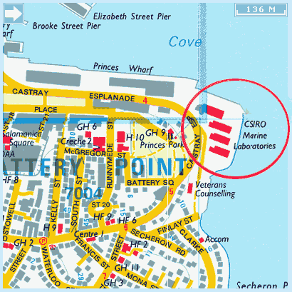
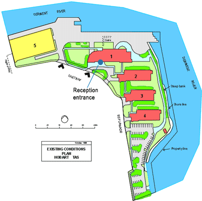
The workshop will be held in the CSIRO Hobart Auditorium immediately inside the main Reception entry of Building 1

CSIRO Marine and Atmospheric Research
Castray Esplanade
HOBART TAS 7000
Australia

Note: There will be no parking available on the CSIRO premesis for workshop participants

Hotels

No block booking has been arranged for this meeting. The following is information on four hotels that offer preferential rates for CSIRO. An alternative is to look for options on websites such as wotif.com. We advise participants to make their reservations early.

To make a reservation with the following hotels at CSIRO rates, quote the booking code "CSIRO-SeaLevel"

St Ives Motel

Deluxe studio double $139
Deluxe studio twin $139 (maximum 2 people)
Deluxe studio twin $159 (maximum 3 people)
Deluxe studio imperial $153
2 Bedroom $179 (if an extra bed is required an extra $20.00 charge per night. Subject to availability)

Room configuration is as follows:
Deluxe studio double - Queen size bed
Deluxe studio twin - Queen size bed & a single bed
Deluxe studio Imperial - King size bed & a guaranteed balcony
2 bedroom - Queen size bed in the main bedroom, 2 single beds in the second
bedroom & bathroom upstairs. Down stairs is the kitchenette & living areas.

All rooms have a kitchenette, which has a stove top , microwave & fridge. These rates apply provided bookings are made direct with the hotel. A credit card is required to secure the booking, paying one nights deposit. Internet is charged at 5c per mb.

Quest Waterfront

Hotel Room - $165
Studio Delux - $185
Family Suite - $261

Room configuration:
Hotel room - Queen bed, Tea and coffee facilities and ensuite bathroom (No. of guests included in rate = 2)
Studio Delux - QB and 1 single bed, kitchenette, Movie Vue, ensuite bathroom. Can request extra single bed (no. of guests included in rate = 3)
Family Suite - QB in living area & 2 SB in separate room (can be made into a king sized bed), kitchenette, Movie Vue, 1 bathroom. Can request extra single bed (no. of guests included in rate = 4)

Bookings of 3 nights or longer will require 1 night as a deposit. Breakfast is available at two locations, Harbour Lights Café and Customs House Hotel, where meals can be charged back to you room account at Quest Waterfront.

Lenna of Hobart & Salamanca Terraces

Lenna of Hobart
Park View Room - $159
Harbour View Room - $189
Family Room - $219
King Suite - $219.00
 
Salamanca Terraces
1 Bedroom Apartment  $175.00

The in-room internet costs are as $2 per hour or $14.95 per day (note this is not wireless internet). Complimentary wifi and computer station are in the Chandelier Lounge Bar at Lenna. Breakfast is $19.50 per person for the continental buffet or our a la carte menu starts at $12.50.  Room service breakfast is offered at Lenna of Hobart.
 
To book can contact Samantha Jarvis, Reservations Manager at sam@lenna.com.au or phone 03 62323900
Credit card details are required to guarantee the booking and an email address to send confirmation details.

Old Woolstore Apartment Hotel

Hotel Room - $132 per room, per night, room only (rate covers 1-2 people, 1x queen bed or 2x separate beds)
Studio Apartment - $152 per apartment, per night, room only (rate covers 1-2 people, 1x queen bed)
One Bedroom Apartment - $172 per apartment, per night, room only (rate covers 1-2 people, 1x queen bed OR 2x single beds)
Two Bedroom Apartment - $252 per apartment, per night, room only (rate covers up to 4 people, 2x queen beds OR 1x queen & 2x singles)
 
The above rates are inclusive of tax (GST) and are available only when booked directly with the hotel.  Additional guests/rollaway beds cost an extra $40 per night. Internet is available for $5 for 24 hours.
Breakfast is available in the Stockman’s Restaurant from 0630-1000 and 2013 rates are: Continental $14.00 and Full Buffet $19.50.

For bookings contact the Reservations Team on 1800 814 676 or email (reservations@oldwoolstore.com.au).

Visa Information

Under Australia's universal visa system, all visitors to Australia must have a valid visa to travel to and enter Australia (other than New Zealand passport holders who will normally be granted a Special Category visa on arrival, provided they meet health and character requirements; and permanent residents of Norfolk Island who may be granted a Permanent Resident of Norfolk Island visa on arrival).

Business Visitor Visa - is the most appropriate option for delegates fulfilling an official role such as speaking/presenting at an event, or if the delegate is employed and is travelling to Australia to be involved in an activity that is related to their profession.

For information on how to apply for a  Business Visitor Visa, please see the document: Business Events Factsheet October 2012.pdf

Visa applicants must demonstrate that they meet all the legislative requirements for an Australian visa. For additional background relating to visas for people to come to Australia for a business-related visit,  see: http://www.immi.gov.au/skilled/business/business-visit-visa-options.htm

Applicants applying for a paper-based visa should lodge their application at least 6-8 weeks before their intended travel date to Australia. Those applying for their visa electronically should do so at least 2 weeks prior to travel. Note the implementation of the new Biometrics Program for visa applicants lodging a paper-based application in the following countries; France, Jordan, Kenya, Lebanon, Malaysia, Sri Lanka, Bahrain, Bangladesh, Zimbabwe, Kuwait, Oman, Qatar, Saudi Arabia, United Arab Emirates and Yemen. For information see: http://www.immi.gov.au/allforms/biometrics/offshore/countries.htm

Monday 18 February 2013

Context and Observations of Sea level and Land Ice

Morning Chair: Simon Marsland

08:00 - 08:30 Registration and coffee/snack  
08:30 - 08:40 Bruce Mapstone
Welcome from Chief, CSIRO Marine and Atmospheric Research
 
08:40 - 08:50 Simon Marsland
Welcome from organising committee and logistics
 
08:50 - 09:50

John Church
Challenges in improving sea-level projections

 
09:50 - 10:20 Break  
10:20 - 11:20

Mark Tamisiea
The ‘static’ boundaries of sea level change

 
11:20 - 12:20

Robert Kopp
Interpreting the noisy geological record of ancient sea level changes: What can the Quaternary tell us about ice sheet stability?

12:20 - 12:40

Catia Domingues
Global and regional thermosteric sea level changes since 1970

 
12:40 - 14:00 Lunch  

Afternoon Chair: Gokhan Dababasoglu

14:00 - 15:20 Poster Session  
15:20 - 15:50 Break  
15:50 - 16:10

Matt King
Lower GRACE estimates of Antarctic sea-level contribution

16:10 - 16:30

Will Hobbs
Can we detect long-term, global change from sparse, 135-year-old ocean data?

16:30 - 16:50

Peter Svendsen
Confidence and sensitivity of sea-level reconstructions

 
17:00 - 20:30 Reception, BBQ and posters  


Tuesday 19 February

Land Ice Theory and Models; Ocean Ice Shelf Interactions

Morning Chair: Stephanie Downes

08:00 - 08:30 Coffee/snack  
08:30 - 09:30

David Holland
Ice-ocean interaction observations and modeling, Greenland and Antarctica

09:30 - 09:50

Natalia Gomez
A coupled ice sheet - sea level model applied to Antarctica through the last 40,000 years

 
09:50 - 10:20 Break  
10:20 - 11:20

Patrick Heimbach
Understanding the Dynamic Response of Greenland’s Marine Terminating Glaciers to Oceanic and Atmospheric Forcings

11:20 - 12:20

Phillip Jones for Wiliam Lipscomb
Modeling the Antarctic ice sheet in CESM with Glimmer-CISM

12:20 - 12:40

Ben Galton-Fenzi
Processes controlling ice shelf melting in East Antarctica

 
12:40 - 14:00

Lunch


Afternoon Chair: Matthew England

14:00 - 15:00

Eric Larour
Uncertainty quantification of ice sheet mass balance projections using ISSM

 
15:00 - 15:20

Alberto Naveira Garabato
Evidence of accelerating glacial melt in Antarctic coastal sea level rise

 
15:20 - 15:50 Break  
15:50 - 16:50

Hartmut Hellmer
Southern Ocean ice shelf melting in a warming climate

 
16:50 - 17:10

Jianjun Yin
Different magnitudes of projected subsurface ocean warming around Greenland and Antarctica

17:10 - 18:00

Synthesis and discussion
Lead: Detlef Stammer and Jonathan Gregory


Wednesday 20 February

Ocean Model and Coupled Model Simulations

Morning Chair: Catia Domingues

08:00 - 08:30 Coffee/snack  
08:30 - 09:30

Stephen Griffies
Sea level simulated in a suite of forced global ocean-ice models

09:30 - 09:50

Benoit Meyssignac
Anthropogenic forcing fingerprint on the tropical Pacific sea level trend pattern from the CMIP5 simulations of the 21st century

09:50 - 10:20 Break  
10:20 - 11:20

Jonathan Gregory
Twentieth-century global-mean sea level rise: is the whole greater than the sum of the parts?

11:20 - 12:20

Detlef Stammer
Observed and simulated present-day and future regional sea level changes

 
12:20 - 12:40

Aimee Slangen
Projecting regional sea-level changes for the 21st century

12:40 - 14:00 Lunch  

Afternoon Chair: Stephen Griffies

14:00 - 15:00

Bernadette Sloyan
Southern Ocean water mass changes

 
15:00 - 15:20

Stephanie Downes
Model representation of Southern Ocean bottom water mass formation and circulation

 
15:20 - 16:00

Synthesis and Discussion
Lead: Stephen Griffies

 
16:00 Break and Adjourn  


Abstracts

Sea level change and IPCC AR5
John Church
CSIRO, Australia

Global and regional thermosteric sea level changes since 1970
Catia M. Domingues, T. Boyer, S. Good, N. White, P. Barker, J. Dunn, S. Wijffels, J. Church, N. Bindoff

Antarctic Climate and Ecosystem Cooperative Research Centre (ACE CRC), Australia

Thermosteric sea level (ThSL) is a major component of the global mean sea level rise observed during the late 20th century, and is projected to continue through the 21st century and beyond. At global scale, thermosteric sea-level rise is explained by the expansion in volume of the global ocean due to a net increase in ocean heat content over the past 50 years. At regional level, geographical patterns are produced in response to dynamical processes, with some areas experiencing variations above and others below the observed global mean. In this talk, we first provide an overview of the challenges in estimating ThSL for the upper 700 m of the ocean, from sparse and unevenly distributed subsurface ocean temperature data, measured by a large and changing mix of instruments. We then illustrate the impact of different instrumental bias corrections and mapping approaches on the global evolution and spatio-temporal variability of ThSL estimates.

Processes controlling ice shelf melting in East Antarctica
Benjamin K. Galton-Fenzi

Antarctic Climate & Ecosystems Cooperative Research Centre, Australia

There is a critical need to improve the ability of global ocean models to represent important coastal features and processes that control the supply of oceanic heat to ice shelves. Ice shelves in East Antarctica are showing thinning, although at lower rates than in the Western Peninsula region, sug-
gested to be caused by enhanced melting by warmer coastal oceans. However, the temperature of East Antarctic coastal seas, unlike those in the West, is primarily dependent on the presence of relatively cold and salty Dense Shelf Water (DSW). DSW is created at the sea surface due to sea ice formation
processes primarily in localised coastal leads and polynyas and is an important ingredient in the formation of Antarctic Bottom Water. Results are presented from both observations and from several regional models and a circum-Antarctic model, that are used to investigate the oceanic processes
that determine ice shelf melting. In areas of low polynya activity or under a future reduction of sea ice growth from polynyas, relatively warmer waters can instead occupy the continental shelf and increase ice shelf melting.

Evidence of accelerating glacial melt in Antarctic coastal sea level rise
Alberto Naveira Garabato
National Oceanography Center, UK

The subpolar Southern Ocean is a region of great climatic importance, hosting intense air - sea - ice interactions with far-reaching consequences for global ocean circulation and sea level. Glaciological measurements suggest that these interactions may be undergoing a profound change as a result of an accelerating glacial discharge into the Antarctic coastal seas, yet current evidence of this change is suggestive at best. In this work, we analyse the altimetric record of sea surface height (SSH) during the largely ice-free summer season to show that the subpolar Southern Ocean has experienced a pronounced, quasi-circumpolar positive trend in summertime SSH of ~1 mm / yr above the global-mean sea level rise since the early 1990s. The signal is generally amplified near the coast and in the Pacific sector, is broadly consistent in magnitude and geography with in situ observations of upper-ocean freshening in several sectors of the Antarctic shelf seas, and exhibits a magnitude that is approximately twice that implied by glaciological measurements of the accelerating glacial discharge. All in all, our analysis indicates that the widespread sea level rise in the subpolar Southern Ocean primarily reflects a halosteric response to the recent acceleration in Antarctic ice mass loss on decadal time scales, although wind forcing plays a significant role in explaining SSH variability on interannual and shorter time scales.

A coupled ice sheet - sea level model applied to Antarctica through the last 40,000 years
Natalya Gomez1, David Pollard2, Jerry X. Mitrovica1

1 Harvard University, USA
2 Pennsylvania State University, USA

An instability mechanism is predicted for marine ice sheets resting upon reversed bed slopes whereby ice-sheet thinning or rising sea level leads to irreversible retreat of the grounding line. Previous analyses of marine ice-sheets have considered the influence of a sealevel perturbation on ice-sheet stability by assuming a geographically uniform, or eustatic, change in sea level. However, gravitational, deformational and rotational effects associated with changes in the volume of grounded ice lead to markedly non-uniform spatial patterns of sea-level change. In particular, a gravitationally self-consistent sea-level theory predicts a sea-level fall in the vicinity of a shrinking ice sheet that is an order of magnitude greater amplitude than the sea-level rise that would be predicted assuming eustasy. I will highlight the stabilizing influence of local sea-level changes on marine ice sheets using an ice sheet stability theory and consider the impact of this stabilizing mechanism on the timescale of ice sheet retreat using a 1D dynamic coupled ice sheet – sea level model. I will also introduce the results of simulations in which post-glacial sea-level physics is coupled to a 3D, dynamic ice sheet-shelf model, and applied to Antarctica through the last 40,000 years. The coupled model simulates far-field and near-field sea-level change, capturing interactions due to gravitational and deformational effects of varying ice mass on the proximal ocean and grounding-line depths. Results will focus on total ice volume through time, ice distributions and sea levels at the Last Glacial Maximum and present and be compared to measurements of relative sea level and present-day uplift rates throughout Antarctica.

Twentieth-century global-mean sea level rise: is the whole greater than the sum of the parts?
Jonathan Gregory
Walker Institute and Met Office Hadley Centre, UK

Confidence in projections of global-mean sea-level rise (GMSLR) depends on an ability to account for GMSLR during the 20th century. There are contributions from ocean thermal expansion, mass loss from glaciers and ice sheets, groundwater extraction and reservoir impoundment. We have made progress towards solving the "enigma'' of 20th-century GMSLR---that is, the observed GMSLR has been found to exceed the sum of estimated contributions, especially for the earlier decades. We propose that: thermal expansion simulated by climate models may previously have been underestimated owing to their not including volcanic forcing in their control state; the rate of glacier mass loss was larger than previously estimated, and was not smaller in the first than in the second half of the century; the Greenland ice-sheet could have made a positive contribution throughout the century; groundwater depletion and reservoir impoundment, which are of opposite sign, may have been approximately equal in magnitude. We show that it is possible to reconstruct the timeseries of GMSLR from the quantified contributions, apart from a constant residual term which is small enough to be explained as a long-term contribution from the Antarctic ice-sheet. The reconstructions account for the approximate constancy of the rate of GMSLR during the 20th century, which shows small or no acceleration, despite the increasing anthropogenic forcing.  Semi-empirical methods for projecting GMSLR depend on the existence of a relationship between global climate change and the rate of GMSLR, but the implication of our closure of the budget is that such a relationship is weak or absent during the 20th century.

Dynamic sea level in a suite of CORE-forced global ocean-ice simulations
Stephen Griffies
NOAA/GFDL, USA

We analyze global and regional dynamic sea level in a suite of ~15 global ocean-ice simulations using the inter-annual CORE forcing (years 1948-2007).  Two basic questions are considered: 1/ Do CORE-forced simulations reproduce the observed thermosteric sea level rise occurring during the second-half of the 20th century? 2/ Do CORE-forced simulations reproduce the observed patterns of sea level change seen during the satellite era?

Greenland ocean - land ice / ice sheet interactions
Patrick Heimbach
MIT, USA

Southern Ocean ice shelf melting in a warming climate
Hartmut Hellmer and R. Timmermann
Alfred Wegener Institute for Polar and Marine Research, Germany

The Antarctic ice sheet loses mass at its fringes bordering the Southern Ocean. At this boundary, warm circumpolar water can override the continental slope front, reaching the grounding line through submarine glacial troughs and causing high rates of melting at deep ice-shelf bases. The interaction between ocean currents, continental bathymetry, and shelf hydrography is thus likely to influence future rates of ice loss. The evolution of basal loss in a warming climate is presented for ten Antarctic ice shelves, based on the output of two coupled ice– ocean models (BRIOS and FESOM) both forced by the IPCC-SRES E1 and A1B scenario-related atmospheric outputs of the HadCM3 and ECHAM5/MPIOM climate models. Projections of future ice shelf basal melting are similar with regard to the scenarios applied but differ substantially between the climate models used, with the HadCM3 output causing the most significant changes in continental shelf temperatures. All ice shelves face a possible increase in basal melting with the biggest changes occuring at the base of the Filchner-Ronne Ice Shelf. A redirection of the coastal current into the Filchner Trough and underneath the Filchner–Ronne Ice Shelf during the second half of the twenty-first century may lead to increased flow of warm open ocean waters into the deep southern ice-shelf cavity. Here, water temperatures can increase by more than 2oC boosting average basal melting from 0.2 m/yr, or 82 Gt/yr, to almost 4 m/yr, or 1,600 Gt/yr. The analysis of the results suggests that the changes are caused primarily by the freshening of the shelf water masses and an increase in ocean surface stress in the southeastern Weddell Sea, both due to reduced sea ice formation and a thinning of the formerly consolidated sea-ice cover. A projected further increase of ice loss at the base of the Filchner–Ronne Ice Shelf to 2,500 Gt/yr for the year 2199 is caused by a gradual warming of the deep Weddell Sea in FESOM and does not occur in the regional BRIOS simulation.

Can we detect long-term, global change from sparse, 135-year old ocean data?
Will Hobbs1 and J Willis2
1 IMAS, Australia
2 Caltech/NASA Jet Propulsion Laboratory, USA

Since almost all the climate system's heat capacity resides in the global ocean, observed long-term changes in ocean heat content (OHC) are invaluable for estimating the plant's radiative imbalance. Several sudies produce such estimates from in situ observations, but generally these estimates are restricted to the late 20th century onwards, prior to which there was little global observation. Recent studies have compared modern Argo-based estimates of global ocean temperature with estimates from the 1873-1876 HMS Challenger expedition, the first global-scale survey of the subsurface oceans, and report a significant temperature difference between Challenger and Argo periods. In this work, using simulations from the CMIP5 suite of earth system models, we ask firstly whether this temperature difference between two relatively short time periods can be attributed to an anthropogenic warming over the entire global ocean, and secondly how well this difference represents a truly global change, We demonstrate that it is extremely unlikely that the temperature difference along the Challenge cruise track could be caused by natural variability alone. Furhtermore, the Challenger data provides a reasonable proxy for the true 135-year global temperature difference.

Ice-ocean interaction observations and modeling, Greenland and Antarctica
David Holland
Courant Institute, USA

A review of ice-ocean interaction studies, spanning observational and modeling, covering both Greenland and Antarctica is presented. From an observational point of view the past decade has seen a considerable leap forward in observational studies in Greenlandic fjords (e.g. Ilulissat in Greenland and Pine Island in Antarctica to mention just two representative locations). Surprising results emerge from such studies, partially suggesting that still more observational research is yet required in order to build a more definitive view of the mechanisms involved in ice-ocean interaction. Modeling studies have also progressed, giving some insight into the circulation involved in ice-ocean interaction and at the same time suggest a forward pathway for both future strategies for observational campaigns and coupled models.

Modeling the Antarctic ice sheet in CESM with Glimmer-CISM
Phil Jones (on behalf of William Lipscomb)
LANL, USA

We will describe the Community Ice Sheet Model (CISM) and the coupling of this ice sheet model to the climate system within the Community Earth System Model (CESM) for the purpose of performing projections of future sea level rise in climate change scenarios.  The Glimmer-CISM model will be presented with an emphasis on methods for coupling this model with both the land surface and the ocean components.  We have implemented a new boundary scheme for simulating ocean flow under ice shelves within a climate system model.  Early results from large-scale simulations around the Antarctic continent will be shown.

Lower GRACE estimates of Antarctic sea-level contribution
M. King1,2, R. Bingham1, P. Moore1, P. Whitehouse3, M. Bentley3, G. Milne4
1 School of Civil Engineering and Geoscience, UK
2 School of Geography and Environmental Studies, University of Tasmania, Australia
3 Department of Geography, Durham University, UK
4 Department of Earth Sciences, University of Ottawa, Canada

We present a new estimate of the contribution of the Antarctic Ice Sheet to sea-level rise during the GRACE era. We correct the GRACE data for the ongoing effects of Glacial Isostatic Adjustment (GIA) by employing a new model that has been developed using a numerical ice-sheet model constrained by glaciological and geological data, and Earth viscosity models that optimise the fit to relative sea-level data and GPS observations of present-day uplift. Error bars provided with the GIA model, which reflect uncertainty in both the Earth model and ice history, enable us to place bounds on the contribution of present-day ice-mass change to the observed GRACE signal. We seek to reproduce the magnitude and spatial distribution of the GIA-corrected GRACE rates using a forward model approach considering 26 continental basins plus others outside the grounded ice sheet. throughout Antarctica during the last decade that is required to. We pay particular attention to the sensitivity of the derived spatial patterns of change due to leakage of signal between basins. Due to a reduced GIA correction compared to older models, we obtain substantially smaller rates of ice mass loss, and hence sea level rise, than previous studies.

Interpreting the noisy geological record of ancient sea level changes: What can the Quaternary tell us about ice sheet stability?
R. Kopp

Rutgers University, USA

Sea level rise - driven in part directly by changes in ocean temperature and in part by melting land ice - figures prominently among the effects of a warming climate. Melt dynamics are, however, complicated and challenging to project using forward models. The geological record of past sea level changes provides a complementary source of information about ice sheet stability. Yet this record is composed of proxies that are uncertain in their meaning, uncertain in their ages, and reflect sea level as seen through the filter of a range of physical process that cause local sea level change to deviate, and sometimes even differ in sign, from changes in mean global sealevel. In this talk, I will discuss the challenges of inferring past sea level and ice sheet changes from geological observations, while taking into account both uncertainties and our understanding of the relevant physics. I will also explore what inferred sea level during past warm periods may be able to tell us about the stability of ice sheets in the coming centuries

Uncertainty quantification of ice sheet mass balance projections using ISSM
Eric Larour
JPL, USA

Anthropogenic forcing fingerprint on the tropical Pacific sea level trend pattern from the CMIP5 simulations of the 21st century
Benoit Meyssignac1, D. Salas y Melia2 and A. Cazenave1
1 LEGOS/CNES, France
2 CNRM, France

In a recent study, Meyssignac et al. (2012) investigated how the spatial trend patterns in the tropical Pacific sea level –as revealed by satellite altimetry- evolved in space and time during the last decades and centuries. For that purpose, they analysed data from past 2-D sea level reconstructions (over 1950-2009) as well as model outputs from multi-centennial control runs and 20th century runs derived from an ensemble of 8 CMIP3 coupled climate models. They showed that the sea level trend patterns, computed over successive 17-year windows (i.e., corresponding to the satellite altimetry operating period at the time of the study) using past 2-D sea level reconstruction data, fluctuated with time following a low frequency modulation of ENSO (period between 25 and 30 years). A similar behaviour was found in multi-centennial control runs of the coupled climate models with constant external forcing (i.e. with no anthropogenic emissions, no solar/volcanic variability). In the 20th century model runs that include all external forcings, the tropical Pacific sea level trend pattern appeared to have fluctuated at a slightly higher frequency. But the difference with the control runs appeared too small to be significant, suggesting that tropical Pacific sea level trend pattern reported by satellite altimetry over the last ~2 decades essentially reflects the internal variability of the climate system. In this presentation, we go a step further and analyse CMIP5 simulations for the 21st century forced by specified GHG concentrations consistent with high anthropogenic emissions scenario (RCP8.5 runs). The objective is to determine how the observed tropical Pacific sea level trend pattern fluctuations evolve in such a high GHG concentration scenario, and to eventually detect the anthropogenic forcing fingerprint. We apply a similar analysis as in Meyssignac et al. (2012) with multi-centennial control runs and RCP8.5 runs from an ensemble of 21 CMIP5 coupled climate models. The results provide a first estimation of the minimum level of anthropogenic forcing that allows a detection of its impact (above the large signal generated by the internal climate variability) on the tropical Pacific sea level trend pattern.

Observations of ice-ocean interactions in Greenland and Antarctica and impact on mass balance
Eric Rignot
University of California, Irvine, USA

Southern Ocean water masses and sea level from models and observations
Bernadette Sloyan
CSIRO, Australia

Observed and simulated present-day and future regional sea level change
Detlef Stammer1, M. Carson1, A. Köhl1, A. Slangen2, C.A. Katsman3, R.S.W. van de Wal2 and L.L.A.Vermeersen4;5
1 Center for Earth System Research and Sustainability (CEN), University of Hamburg, Germany
2 Institute for Marine and Atmospheric research Utrecht (IMAU), Utrecht University, The Netherlands
3 Royal Netherlands Meteorological Institute (KNMI), The Netherlands
4 Delft Climate Institute, Faculty of Aerospace Engineering, TU Delft, The Netherlands
5 Royal Netherlands Institute for Sea Research (NIOZ), The Netherlands

Sea level is changing not only on global average, but also shows pronounced regional changes. Those regional changes can vary on a broad range of timescales, and in some regions can even lead to a reversal of long-term global mean sea level trends. The underlying causes are associated with dynamic variations in the ocean circulation as part of climate modes of variability and with an isostatic adjustment of Earth’s crust to past and ongoing changes in polar ice masses and continental water storage. The talk will focus on present day and future regional sea level changes resulting from changes of the ocean circulation and/or changes in the heat and freshwater content. Present-day regional sea level changes appear to be caused primarily by natural climate variability. However, the imprint of anthropogenic effects on regional sea level will grow with time as climate change progresses, and toward the end of the twenty-first century, recent CMPI5 results suggest that regional sea level patterns will be a superposition of climate variability modes and natural and anthropogenically induced static sea level patterns.

Condence and sensitivity of sea-level reconstructions
P. Svendsen
National Space Institute, Technical University of Denmark, Denmark

For the last two decades, satellite altimetry has provided a near-global view of spatial and temporal patterns in sea surface height (SSH). When combined with records from tide gauges, a historical reconstruction of sea level can be obtained; while tide gauge records span up to 200 years back, their combined quality for reconstruction purposes is limited by the sparsity of their geographical distribution and other factors. We examine both a traditional EOF analysis of sea surface height, and another method known as minimum/maximum autocorrelation factors (MAF), which takes into account the spatial nature of the data fields. We examine the sensitivity of a reconstruction with respect to the length of calibration time series, and the spatial distribution of tide gauges or other proxy data. In addition, we consider the eect of isolating certain physical phenomena (e.g. ENSO) and annual signals and modelling these outside the reconstruction. The implementation is currently based on data from compound satellite datasets (i.e., two decades of altimetry), and the Simple Ocean Data Assimilation (SODA) model, an existing reconstruction, where a calibration period can be easily extracted and our model's basic performance can be relatively easily assessed. This means that we will consider only the last 50-60 years of sea level data. This is a preliminary analysis to pave the way for an improved reconstruction in the Arctic area, a major focus of my PhD project.

The “Static” Boundaries of Sea Level Change
Mark Tamisiea
NOC, UK

As mass moves between the ice sheets and the ocean, the resulting loading causes both crustal deformation and changes to the Earth's gravity field, the two bounding surfaces of sea level. These “static” changes, also termed self-attraction and loading (SAL), introduce both local and global effects. SAL produces large-scale patterns in the resulting sea level change and causes apparent differences in regional measurements derived from tide gauges and altimetry. Near marine-based ice sheets that are losing mass, the resulting crustal uplift can impact the grounding line evolution. Variations in continental water storage can generate SAL effects that bias coastal sea level measurements compared to the global average. Even the sea level changes from thermal expansion, which drives mass onto the continental shelves, are amplified by SAL effects. In addition to the static changes caused by present-day motion of mass, the Earth and ocean are also still responding to past changes of the ice sheets, termed glacial isostatic adjustment (GIA). In this talk, I will review the different aspects of static sea level change, how different measurements are affected, and implications for future projections and understanding.

Model representation of Southern Ocean bottom water mass formation and circulation
S. M. Downes1, A. Gnanadesikan2, S. M. Grffies3 and J. L. Sarmiento4
1 Research School of Earth Sciences, The Australian National University, Australia
2 Department of Earth and Planetary Sciences, Johns Hopkins University, USA
3 NOAA/Geophysical Fluid Dynamics Laboratory, USA
4 Program in Atmospheric and Oceanic Sciences, Princeton University, USA

The formation and circulation of Antarctic bottom waters is a key process in the distribution of heat in the abyssal ocean. However, associated ice and ocean model parameterizations create a biased representation of bottom waters. The current state of representation of bottom waters in coarse resolution models is analyzed using fully-coupled general circulation climate models and an assimilated solution. In a density framework, it is shown that primary model-model differences for deep and bottom waters (that is, the lower limb of the overturning circulation) are linked with different surface buoyancy fluxes, ocean density field and diapycnal mixing. Possible suggestions for physical circulation processes requiring attention in the modeling community will also be put forward.

Projecting regional sea-level changes for the 21st century
Aimee B.A. Slangen1, M. Carson2, C.A. Katsman3, R.S.W. van de Wal1, A. Köhl2, L.L.A.Vermeersen4;5 and D. Stammer2

1 Institute for Marine and Atmospheric research Utrecht (IMAU), Utrecht University, The Netherlands
2 Center for Earth System Research and Sustainability (CEN), University of Hamburg, Germany
3 Royal Netherlands Meteorological Institute (KNMI), The Netherlands
4 Delft Climate Institute, Faculty of Aerospace Engineering, TU Delft, The Netherlands
5 Royal Netherlands Institute for Sea Research (NIOZ), The Netherlands

Sea-level rise is one of the most important consequences of a warming climate, affecting many densely populated coastal communities. Obtaining local information on sea-level change is therefore essential for adequate coastal management. Increased scientific understanding of the contributing processes now allows us to go from global mean projections to regional patterns. We will present the latest regional sea-level projections for the 21st century based on the new CMIP5 climate model ensemble, for a moderate (RCP4.5) and a warm (RCP8.5) climate change scenario. Compared to previous estimates, we now include more processes that influence regional sea-level changes, and also show the uncertainty estimates for these processes. Processes considered are the gravitational effects resulting from land ice changes and groundwater depletion, the projected ocean density variations and associated changes in ocean dynamics, the changes in atmospheric pressure loading, and the contribution of glacial isostatic adjustment. In total, the two climate change scenarios yield global mean changes of 0.52±0.18 m and 0.71±0.25 m respectively. Regionally however, values of up to 30% above the global mean are projected in the equatorial and subtropical regions and around Australia and Southern Africa. We also find values of 50% below the global mean in for instance the Arctic Ocean. In addition we now provide a more rigorous error estimate for all the contributions.

Different magnitudes of projected subsurface ocean warming around Greenland and Antarctica
Jianjun Yin1, Jonathan Overpeck1, Stephen Griffies2, Aixue Hu3, Joellen Russell1 and Ronald Stouffer2
1 Department of Geosciences, University of Arizona
2 GFDL
3 NCAR

The observed acceleration of outlet glaciers and ice flows in Greenland and Antarctica is closely linked to ocean warming, especially in the subsurface layer. Accurate projections of ice-sheet dynamics and global sea-level rise therefore require information of future ocean warming in the vicinity of the large ice sheets. Here we use a set of 19 state-of-the-art climate models to quantify this ocean warming in the next two centuries. We find that in response to a mid-range increase in atmospheric greenhouse-gas concentrations, the subsurface oceans surrounding the two polar ice sheets at depths of 200-500 m warm substantially compared with the observed changes thus far. Model projections suggest that over the course of the twenty-first century, the maximum ocean warming around Greenland will be almost double the global mean, with a magnitude of 1.7-2.0°C. By contrast, ocean warming around Antarctica will be only about half as large as global mean warming, with a magnitude of 0.5-0.6°C. A more detailed evaluation indicates that ocean warming is controlled by different mechanisms around Greenland and Antarctica. We conclude that projected subsurface ocean warming could drive significant increases in ice-mass loss, and heighten the risk of future large sea-level rise.